
Garmin Montana Series GPS Comparison
Wednesday, July 7, 2021 — 0 Comments

Here’s How the Montana Models are Different
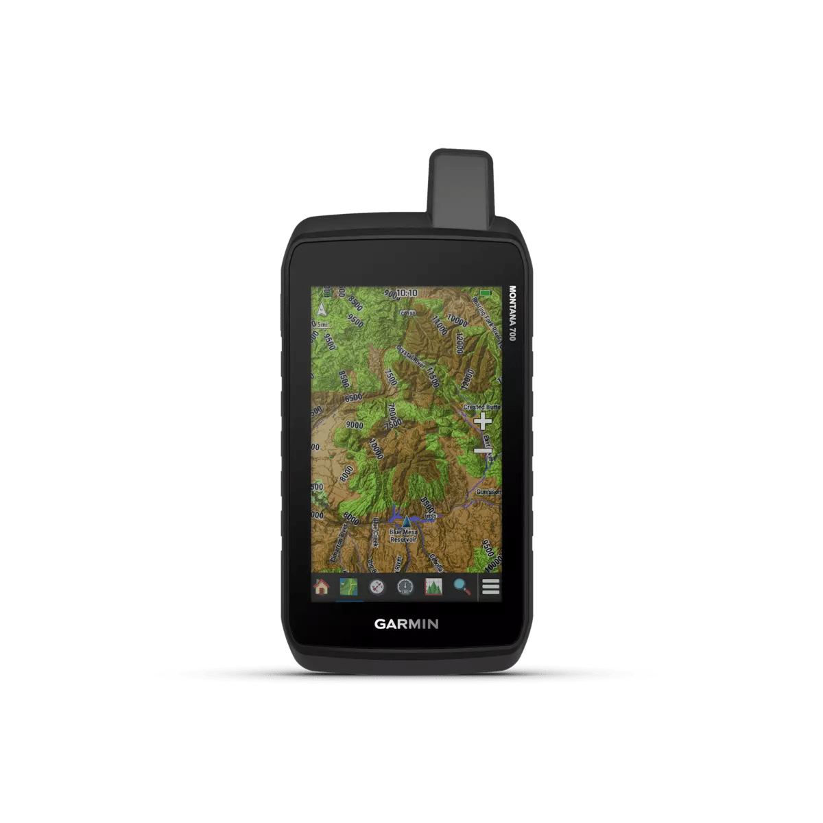
The Montana series are large, dual-orientation touchscreen GPS navigators good for hunting, hiking, boating, ATV and other outdoor adventures.
The new Garmin Montana 700 series was released in August 2020 and features rugged military-grade construction, TopoActive maps, direct-to-device downloads of BirdsEye Satellite Imagery* and dog tracking.
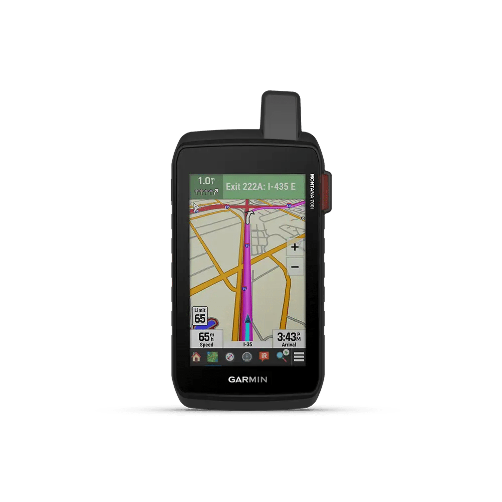
The Montana 700i and 750i also adds two-way messaging via the global Iridium satellite network (subscription required). If you are looking for a smaller, lighter device that also accepts AA batteries on the fly, consider the Montana 610 or 680 (discontinued).
If you are looking for a larger screen, preloaded TopoActive maps, Expedition mode for an ultra-low-power GPS reference, consider the Montana 700.
For two-way satellite communication capabilities, the Montana 700i and 750i (with 8MP camera) are your choices.
*Click here for instructions on how to install BirdsEye Satellite Imagery

| Product | Montana 700 | Montana 700i | Montana 750i | Montana 680 discontinued |
|---|---|---|---|---|
| General | ||||
| Unit Dimensions | 3.4″ x 7.2″ x 1.3″ (8.76 x 18.30 x 3.27 cm) |
3.4″ x 7.2″ x 1.3″ (8.76 x 18.30 x 3.27 cm) |
3.4″ x 7.2″ x 1.3″ (8.76 x 18.30 x 3.27 cm) |
3.4″ x 7.2″ x 1.3″ (8.76 x 18.30 x 3.27 cm) |
| Touchscreen | ✅ | ✅ | ✅ | ✅ |
| Display Size | 2.55″W x 4.25″H (6.48 x 10.80 cm); 5″ diag (12.70 cm) | 2.55″W x 4.25″H (6.48 x 10.80 cm); 5″ diag (12.70 cm) | 2.55″W x 4.25″H (6.48 x 10.80 cm); 5″ diag (12.70 cm) | 2″W x 3.5″H (5.06 x 8.93 cm); 4″ diag (10.2 cm) |
| Display Resolution | 480 x 800 pixels | 480 x 800 pixels | 480 x 800 pixels | 272 x 480 pixels |
| Display Type | WVGA transflective, dual orientation; sunlight readable | WVGA transflective, dual orientation; sunlight readable | WVGA transflective, dual orientation; sunlight readable | bright, transflective 65k color TFT, dual-orientation touchscreen; sunlight readable |
| Weight | 14.0 oz (397 g) with included lithium-ion battery pack | 14.5 oz (410 g) with included lithium-ion battery pack | 14.5 oz (410 g) with included lithium-ion battery pack | 10.2 oz (289 g) with included lithium-ion battery pack; 11.7 oz (333 g) with 3 AA batteries (not included) |
| Battery | rechargeable lithium-ion (included) or 3 AA batteries (not included); lithium recommended | rechargeable lithium-ion (included) | rechargeable lithium-ion (included) | rechargeable lithium-ion (included) or 3 AA batteries (not included); NiMH or Lithium recommended |
| Battery life | GPS Mode: up to 18 hours Expedition Mode: up to 330 hours |
GPS Mode: up to 18 hours GPS Mode, 10 min Tracking: up to 18 hours Expedition Mode: up to 330 hours Expedition Mode, 30 min Tracking: up to 300 hours |
GPS Mode: up to 18 hours GPS Mode, 10 min Tracking: up to 18 hours Expedition Mode: up to 330 hours Expedition Mode, 30 min Tracking: up to 300 hours |
up to 16 hours (lithium-ion); up to 22 hours (AA batteries) |
| Waterproof | ✅ (IPX 7) | ✅ (IPX 7) | ✅ (IPX 7) | ✅ (IPX 7) |
| MIL-STD-810 | ✅ (Thermal, Shock, Water, Vibe) | ✅ (Thermal, Shock, Water, Vibe) | ✅ (Thermal, Shock, Water, Vibe) | ❌ |
| Interface | high-speed USB and NMEA 0183 compatible | high-speed USB and NMEA 0183 compatible | high-speed USB and NMEA 0183 compatible | high-speed USB and NMEA 0183 compatible |
| Memory/History | 16 GB (user space varies based on included mapping) | 16 GB (user space varies based on included mapping) | 16 GB (user space varies based on included mapping) | 4 GB |
| Maps & Memory | ||||
| Basemap | ✅ | ✅ | ✅ | ✅ |
| Ability to add maps | ✅ | ✅ | ✅ | ✅ |
| Preloaded maps | ✅ (TopoActive, by region; Federal Public Lands maps, U.S. only) | ✅(TopoActive, by Region; City Navigator Maps, North America; Federal Public Lands Map, US only) | ✅ (TopoActive, by Region; City Navigator Maps, North America; Federal Public Lands Map, US only) | ❌ |
| Automatic routing (turn by turn routing on roads) for outdoor activities | ✅ (with optional mapping for detailed roads) | ✅ | ✅ | ✅ (with optional mapping for detailed roads) |
| Automatic routing (turn by turn routing on roads) for motorized vehicles | ✅ (with optional mapping for detailed roads) | ✅ | ✅ | ✅ (with optional mapping for detailed roads) |
| Map Segments | 15000 | 15000 | 15000 | 4000 |
| Satellite Imagery How to Install BirdsEye on Montana 700 Series |
✅ (BirdsEye Direct) | ✅(BirdsEye Direct) | ✅ (BirdsEye Direct) | 1 year subscription included but since has been discontinued |
| Includes detailed hydrographic features (coastlines, lake/river shorelines, wetlands and perennial and seasonal streams) | ✅ | ✅ | ✅ | no (additional mapping needed) |
| Includes searchable points of interests (parks, campgrounds, scenic lookouts and picnic sites) | ✅ | ✅ | ✅ | no (additional mapping needed) |
| Displays national, state and local parks, forests, and wilderness areas | ✅ | ✅ | ✅ | no (additional mapping needed) |
| External memory storage | ✅(32 GB max microSD™ card) | ✅ (32 GB max microSD™ card) | ✅ (32 GB max microSD™ card) | ✅(32 GB max microSD™ card) |
| Waypoints/favorites/locations | 10,000 | 10,000 | 10,000 | 4,000 |
| Tracks | 250 | 250 | 250 | 200 |
| Navigation Track Log | 20000 points, 250 saved gpx tracks, 300 saved fit activities | 20000 points, 250 saved gpx tracks, 300 saved fit activities | 20000 points, 250 saved gpx tracks, 300 saved fit activities | 10,000 points, 200 saved tracks |
| Navigation Routes | 250, 250 points per route; 50 points auto routing | 250, 250 points per route; 50 points auto routing | 250, 250 points per route; 50 points auto routing | 200, 250 points per route; 50 points auto routing |
| RINEX Logging | ✅ | ✅ | ✅ | ❌ |
| Sensors | ||||
| High-sensitivity receiver | ✅ | ✅ | ✅ | ✅ |
| GPS, GLONASS & Galileo | GPS, GLONASS & GALILEO | GPS & Galileo | GPS & Galileo | GPS & GLONASS |
| Barometric altimeter | ✅ | ✅ | ✅ | ✅ |
| Electronic Compass | ✅ (tilt-compensated, 3-axis) | ✅ (tilt-compensated, 3-axis) | ✅ (tilt-compensated, 3-axis) | ✅ (tilt-compensated, 3-axis) |
| GPS compass (while moving) | ✅ | ✅ | ✅ | ✅ |
| Daily Smart Features | ||||
| Connect IQ™ (downloadable watch faces, data fields, widgets and apps) | ✅ | ✅ | ✅ | ❌ |
| Smart notifications on handheld | ✅ | ✅ | ✅ | ❌ |
| Weather | ❌ | ✅ | ✅ | ❌ |
| VIRB® Remote | ✅ | ✅ (500 custom map tiles) | ✅ (500 custom map tiles) | ✅ |
| Pairs with Garmin Connect™ Mobile | ✅ | ✅ (Geocache Live) | ✅ (Geocache Live) | ❌ |
| Active Weather | ✅ | ✅ | ✅ | ❌ |
| LiveTrack | ✅ | ✅ | ✅ | ❌ |
| Outdoor Recreation | ||||
| Point-to-point navigation | ✅ | ✅ | ✅ | ✅ |
| Area Calculations | ✅ | ✅ | ✅ | ✅ |
| Custom POIs | ✅ | ✅ | ✅ | ✅ |
| Hunt/fish calendar | ✅ | ✅ | ✅ | ✅ |
| Sun and moon information | ✅ | ✅ | ✅ | ✅ |
| XERO™ Locations | ✅ | ✅ | ✅ | ❌ |
| Geocaching-friendly | ✅ (Geocache Live) | ✅ (Geocache Live) | ✅ (Geocache Live) | ✅ |
| Custom maps compatible | ✅(500 custom map tiles) | ✅ (500 custom map tiles) | ✅ (500 custom map tiles) | ✅ (500 custom map tiles) |
| Picture viewer | ✅ | ✅ | ✅ | ✅ |
| Camera | ❌ | ❌ | ✅(8 megapixel with autofocus; automatic geo-tagging) | ✅ (8 megapixel with autofocus; automatic geo-tagging) |
| inReach remote widget | ✅ | ❌ | ❌ | ❌ |
| LED beacon flashlight | ✅ | ✅ | ✅ | ❌ |
| inReach Features | ||||
| Dog Training | ✅ (when paired to compatible dog track system) | ✅ (when paired to compatible dog track system) | ✅ (when paired to compatible dog track system) | ❌ |
| Contacts | ❌ | ✅ | ✅ | ❌ |
| Interactive SOS | ❌ | ✅ | ✅ | ❌ |
| Send and receive text messages to SMS and email | ❌ | ✅ | ✅ | ❌ |
| Send and Receive Text Messages to Other inReach Device | ❌ | ✅ | ✅ | ❌ |
| Exchange Locations with Other inReach Device | ❌ | ✅ | ✅ | ❌ |
| Mapshare Compatible with Tracking | ❌ | ✅ | ✅ | ❌ |
| Virtual Keyboard for Custom Messaging | ❌ | ✅ | ✅ | ❌ |
| Send Waypoints to Mapshare During Trip | ❌ | ✅ | ✅ | ❌ |
| Send Route Selection to Mapshare During the Trip | ❌ | ✅ | ✅ | ❌ |
| inReach remote compatible | ✅ | ✅ | ✅ | ❌ |
| Outdoor Applications | ||||
| Compatible with Garmin Explore™ app | ✅ | ✅ | ✅ | ❌ |
| Garmin Explore website compatible | ✅ | ✅ | ✅ | ❌ |
| Dog tracking | ✅ (when paired to compatible dog track system) | ✅ (when paired to compatible dog track system) | ✅ (when paired to compatible dog track system) | ❌ |
| Connections | ||||
| Connections Wireless Connectivity | yes (Wi-Fi®, BLUETOOTH®, ANT+®) | yes (Wi-Fi®, BLUETOOTH®, ANT+®) | yes (Wi-Fi®, BLUETOOTH®, ANT+®) | ANT+ |
https://www.youtube.com/watch?v=vEViQSpXHa0